
Training
Section outline
-

-
Videos
On Using Satellite Data to Monitor Flash Floods
Presentation about the use of satellites to monitor potential flash flood conditions.
By Bob Kuligowski, NOAA Center for Satellite Applications and ResearchIntroduction To Remotely Sensed Precipitation Estimation
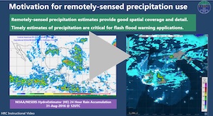
Tutorial presented by Dr. Theresa M. Modrick Hansen, giving an introduction to remotely sensed precipitation estimation relevant to the FFGS.
By the Hydrologic Research Center (HRC)Introduction To Remotely Sensed Precipitation Bias
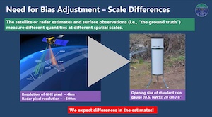
Tutorial presented by Dr. Theresa M. Modrick Hansen, discussing the bias in remotely sensed precipitation estimates, and describing the approach to account for such bias in the FFGS.
By the Hydrologic Research Center (HRC)Satellite Remote Sensing of Precipitation
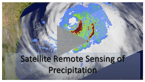
Short presentation on satellite remote sensing of precipitation and its context in within global climate change.
By Tyler RuffTo what degree of accuracy can we measure precipitation from satellites?
In this video, Dr. Viviana Maggioni explains uncertainty associated with precipitation data and errors in satellite-based precipitation estimates, and also presents a "divide and conquer" approach to estimate errors.
By George Mason UniversityBasic Radar Interpretation
This video focuses in on some of the basic aspect of radar including how radar works, the two main types of radar data, and radar features associated with the three main storm types.
By National Weather Service, Weather Forecast Office, Norman, OKWeather radars
Biz Kyte, weather radar network specialist from UK Met Office, explains how we use radars to measure rainfall.
By UK Met OfficeDoppler Radar Rainfall Estimates - A Brief Description
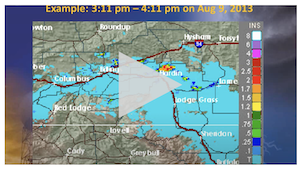
Short video describing two Doppler Weather Radar Precipitation Estimate products.
By National Weather Service, Weather Forecast Office, Billings, MT -
Games
Weather Radars Quiz


Questions in this game check for understanding of how radars can be used in weather forecasting. It is directed to professionals being trained to work in forecasting. Can be played online or printed to use in training events. Prepared by WMO-FFGS.
Weather Radars Match up Game
This is a matching game, useful for revision of concepts related to the use of weather radars in forecasting. It is directed to professionals being trained to work in forecasting. Can be played online or printed to use in training events. Prepared by WMO-FFGS.
-
Online Courses
WMO - Instruments and Observing Methods - Training Material On Weather Radar Systems
This course syllabus provides an overview of the basic features of Meteorological Weather Radars, showing how to operate a Radar and a Radar network.
By WMOWeather Radar Fundamentals
This is a 2-hour module presents the fundamental principles of Doppler weather radar operation and how to interpret common weather phenomena using radar imagery.
By COMET® ProgramRadar Signatures for Severe Convective Weather
This resource is intended for use as a job aid by operational weather forecasters in live warning situations and as a reference tool to better understand some aspects of severe thunderstorm warning events.
By COMET® ProgramLectures on Radar Applications in Mesoscale Meteorology
This is a collection of 11 lectures delivered during the AMS Educational Forum “A Primer on Radar Analysis Techniques Used in Mesoscale Meteorology” held 2005.
By COMET® ProgramRemote Sensing Using Satellite - 2nd Edition
This is an introductory module on remote sensing using satellites. It focus on focus on the visible and infrared channels, those commonly seen on television broadcasts.
By COMET® ProgramWMO Regional Satellite Workshop
This is a collection of 7 lectures delivered during the "Regional Training Course on the Use of Environmental Satellite Data in Meteorological Applications for RAIII and IV," which took place in 2008.
By COMET® ProgramBasic Satellite Imagery Interpretation
This lesson teaches the basics of satellite image interpretation to forecasters, meteorology students, and other interested learners, with an emphasis on the African region.
By COMET® Program
-